Gamba Grass Spead Simulation
This project funded by Territory NRM’s Regional Landcare partnership project delivered two dynamic simulation models to illustrate Gamba Grass spread in the Top-End of the Northern Territory. Both models were designed to help describe challenges around Gamba Grass spread and control. The First Model explores gamba spread and management issues at a regional scale, the second extends some of the basic spread principles to simulate Gamba movement across the whole of the Top-End.
Model 1 Background.
This model seeks to show some of the key factors that moderate Gamba spread and assist with thinks about how it could be most effectively contained. Gamba moves through two primary means; via In situ spread assisted by wind and along networks of roads or rivers.
In situ spread is substantially accelerated by fire, both through increasing the rate of growth and by Gamba seed being ‘thrown’ downwind during fire events. Network spread is primarily due to vehicles carrying seeds to new locations. In this model Gamba pick up and dropping is most likely to occurs at road intersections and intersections with drainage lines. These are the points where people are most likely to stop for utilitarian or recreational (fishing) purposes.
The model has three types of vehicles, town cars that just stick to high-way, bush cars that go on arterial roads, and 4WD cars that can travel on all tracks. When vehicles pick up Gamba they change colour to green. They will keep driving untill either they leave the map area or drop their Gamba seed.
Gamba is also known to travel along drainage lines via animals carrying seed or seed being carried by flowing water. However, the primary means of Gamba moving along watercourses is unknown. In this simulation, drainage spread is modelled using Buffalo, pigs or wallabies as vectors of movement. They will appear and pick up gamba seed when Gamba sprouts along drainage areas.
Another significant mover of Gamba can be grading equipment if not cleaned after working in a Gamba infested area. Using herbicide on Gamba can be effective in killing off gamba areas it although it may require a number of applications
Goals
-
Building a better understanding of the multiple interacting variables affecting Gamba spread.
-
Be understood by both land managers and general landscape users (e.g. tourists, fishers, hunters, kids in schools, general community members, contractors)
-
Engage people who would not otherwise voluntarily take a role in Gamba grass management.
-
Demonstrate that Gamba is a manageable weed in the landscape when people act quickly to address it.
-
Demonstrate how key management interventions could reduce Gamba spread;
-
Don’t burn it
-
Restrict off-road movement in Gamba areas.
-
Monitor likely points of spread
-
Manage small outbreaks.
-
Clean grading machinery
-
Examples
This video shows some of the models features and settings.
This video demonstrates a scenario of a dirty grader line introducing Gamba then being spread with fire.


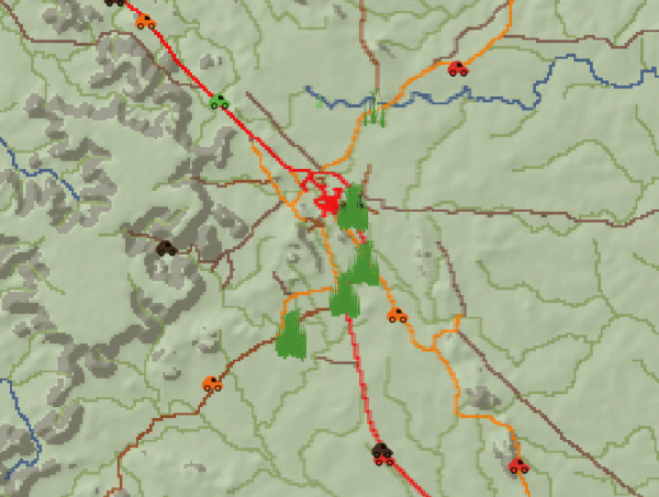
Model 2 Background.
This model seeks to show some of the key factors that moderate Gamba spread and assist with thinking about how it could be most effectively contained. The model simulates how Gamba moves through two primary means; via In situ spread assisted by wind and along networks of roads or rivers. Network spread is primarily due to vehicles carrying seeds to new locations. Modelling was based on expert knowledge from NTG Weeds branch and TNRM staff. The model is initiated with Gamba mapping data of Gamba density produced by Northern Territory Governments (NTG) Weeds Branch.
Model Rules
-
Insitu spread is modeled both as an increase in local density and movement out from a current location. Outward movement probability increases as density increases. The Outward spread is also weighted towards a northwesterly direction to mirror the dominant southeasterly winds that drive seed dispersal.
-
Gamba moves preferentially along road networks with the greatest movement from high-density infestations.
3. Gamba (network) spread probability decreases with distance from current infestation.
4. Gamba is more likely to be dropped and sprout where people stop at road intersections or waterways.
The model is not attempting to predict spread, rather illustrate process and risks associated with gamba spread and control.
An example run of the model is shown below. Year time steps are estimated.

Modeling Software
These models were created in Netlogo modelling and simulation software. This is free open-source
software that can be downloaded and installed on any computer to run the models described.
Model one described above can be downloaded here:


